by David Kutchinski, CEO Sciblue, Inc. La Junta, Colorado, United States of America
Abstract
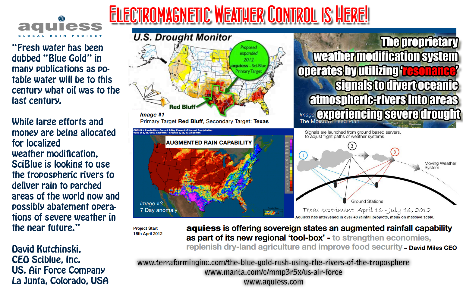
Fresh water has been dubbed “Blue Gold” in many publications as potable water will be to this century what oil was to the last century. Less than three percent of the water on the earth’s surface is fresh water. When we deduct the amount in the ice at each pole and the rivers flowing in uninhabited areas that number is less than one percent. From this amount the nearly 7 billion people on earth use to survive.
This small amount of water is the cause of the gamut of action taken by governments of the world ranging from conservation to armed conflict.
This paper examines the current static status of weather modification methodologies. It further examines the existence of atmospheric ‘rivers’ and their use for a new chapter in weather modification.
Although “Weather Modification” has always been analogous with rain production, this paper will not concentrate only on that aspect but all parts of the use of the ‘river’. This paper will also examine the use of advanced weather modification technologies to severe weather abatement.
Introduction
“We will see 1,000 times more technological progress in the 21st century than we saw in the 20th” -Ray Kurzweil (Author, entrepreneur, scientist and futurist)
“Everybody talks about the weather but nobody does anything about it.” Mark Twain.
In 1946 Schaefer conducted the first cloud seeding demonstration. The success of that process created great anticipation for increased precipitation. With 65 years of hype “proving” glaciogenic seeding the method is, at best, more of an art than a science. Exhaustively controlled experiments were conducted. Under the aegis of the WMO, the Israeli and Italian project were conducted, where over 20 years of testing all yielding negative results. Still, today there are hundreds of companies performing the seeding of clouds with photo processing chemicals and salt around the world. Even with the recent Chinese Olympics being touted as “proof” of glaciogenic seeding practice, it has yet to convince the scientific community.
Meteorologists remain strongly divided, with some thinking it has been demonstrated to have a positive effect, others thinking it has the potential to produce a positive effect but has not been demonstrated, and others thinking it's mostly a scam. - John N-GMost recently, the use of sending Ions into the air has attracted attention with the Swiss company building antenna farms in the UAE. They claim they have produced 52 rainstorms in an area that sees, maybe, two rain events a year. The theory is that these 100 transmitters will send enough charged particles into the atmosphere where the negatively charged ions will tend to rise into the hot air and attract dust. From that point, moisture will be attracted to the “charged dust” and eventually become a cumulus cloud and yield rain.
I hadn't heard about this one, so I Googled it. The first hit was an online article at LiveScience.com, which seems to be a fairly decent description, except that a paragraph sayingThere is no doubt that new technologies have and will try and produce rain. If one believes the global warming people then you would also have to agree that more and more potable water will then be available in the Troposphere. This increase in the moisture of the Troposphere could also yield larger weather events. Hurricanes/cyclones/typhoon can develop larger events with a hotter sea surface temperature (SST) and more moisture in the air.“It is very sad that rain enhancement by methods that have no scientific basis (or at least have never been exposed to a scientific evaluation) get the headlines,” said Roelof Bruintjes, a meteorologist at the U.S. National Center for Atmospheric Research.
was immediately followed by a section titled “How it works”. A better section heading would have been “Why it can’t work”. - John N-G
The one common denominator for all present and future successful weather modification operations will be the understanding and use of the ‘rivers’.
Rivers in the sky
Before the advent of the advanced Electro Optical (EO) weather satellite the entire plethora of images was relegated to the military satellites looking for acts of war on the behalf of other countries. Some of the early EO imagery was taken from aircraft and termed “False Color” as they used processes to attenuate certain light spectrum for mostly geologic (Oil, Gas and Minerals) pursuits. Early weather satellites available to the public were daylight only. Current feeds can aquiess large amounts of data of great use to all parts of the scientific, commercial and ordinary citizen community.
Light Spectrum and product produced:
As readers of Part 2 of my Tyndall Gas Effect series know, this is only a small subset (actually, the most commonly used subset) of the many wavelengths detected by satellite and utilized on the ground. - John N-G
| Wave Length | Product |
| 0.65 µm | Visible |
| 3.9 µm | Short Wave IR |
| 6.7 µm | Water Vapor |
| 10.7 µm | Long Wave IR |
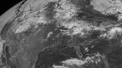
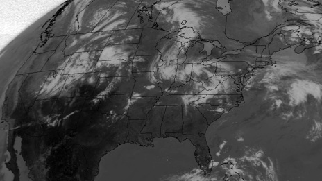
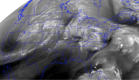
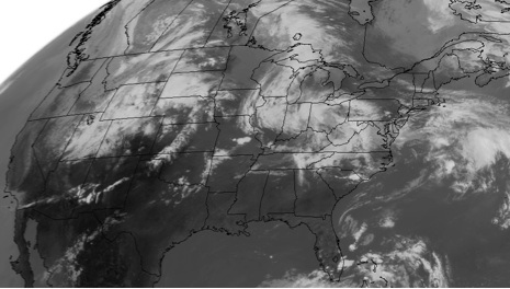
Even to the untrained eye these yield a great deal of data but to the atmospheric scientist they can yield even more. Take the 6.7 µm image taken (Water Vapor) and enhance it with an available filter named “Warm Season Color Curve”. A whole new dataset has emerged.
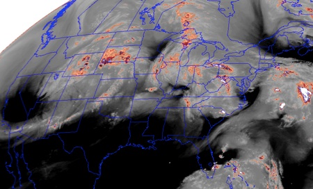
The dry areas are evidenced by the black and the moisture is evidenced by the white with the pink to white scale showing the cloud’s potential for moisture.
This wavelength is most sensitive to moisture in a layer 4-6 miles above the ground. So the black areas are dry in the upper troposphere but could be quite humid near the ground (as, for example, over the Gulf of Mexico). The white to pink enhancement picks out clouds and indicates the temperature of the cloud top. Since temperature decreases with height in the troposphere, a cold cloud top implies a very high cloud, possibly a deep thunderstorm. Aspects of the structure of the cold cloud area or other information can be used to infer whether it's really a deep thunderstorm or just some high cirrus. - John N-GA great example of the Tropospheric rivers is this image in the 6.7 µm range (Water Vapor) taken in the Pacific Ocean. In this you can see the moisture flows that are evidenced in this image.
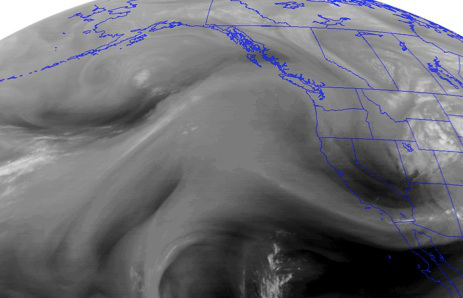
With these tools available, anyone can see that there are rivers of moisture moving in the Troposphere at all times. It also shows where the virtual land (no moisture) is and how it influences these rivers.
"Atmospheric river" is indeed an accepted meteorological phenomenon that has become sufficiently well-established to be written up on Wikipedia. The original name was "tropospheric river". - John N-GRiver Behavior
Particle physics applies both to liquid water molecules in the river and streams and microns of water molecules in the air. While the land liquid can carve mighty openings in solid rock over thousands of years the air molecules can form into rivers that can wipe out towns or forests in hours with floods and tornados.
While geology influences the path of a body of water so does it affect the micron sized H2O water in the air. The geology of a land mass will create different evaporation rates for any water that may fall on it, or move above it. Geology will also absorb the energy from the sun in different ways. Geology can also influence the weather far away.
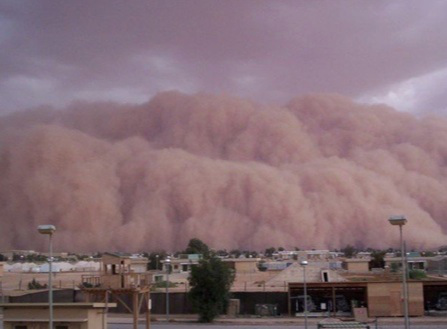
A Haboob (massive sand storm) in Sudan or Iraq will have consequences for weather reaching 1,000 miles from the event. Where if this same atmospheric event (huge downdraft from a massive cumulonimbus cell) had happened in the Congo it would be gone unnoticed in the rest of the region.
The location on earth that the rivers run also has an effect on their course. At the equator you have Hadley cells and in the Polar Regions you have Ferrel cells. At the equator air currents move upward and return to the surface at 30 degrees (approximately 2,000 miles) north and south of the equator. Similar affects happen at the polar region, which is why Ferrel Cells are also called Polar Cells.
Actually, there are three cells: Hadley Cells, Ferrel Cells, and Polar Cells. The usual Internet resources don't do a very good job describing them, so I recommend this YouTube video. Beyond this, a certain change of coordinates that I like yields a single cell in each hemisphere! - John N-GThe tilt of the earth as it changes throughout the year also will have a major influence on these rivers.
Last are the Jet Stream and frontal systems that are constantly changing.
Charting the Rivers
Predicting the constant change of these rivers has long been the motivator to ignore them as a “Bridge Too Far”. In a massive scale such as NRL, NOAA or NASA must address that would be a logical course of action. How could anyone have the resources to input all the data points needed to be able to ‘chart’ the course of the river in the next hour.
NOAA does this routinely, for example with data from the same satellites that produced the images shown above. John N-G
What if we weren’t to look at charting the river on a continental scale but a much smaller one, such as a singularity for one location? This is what SciBlue is attempting. By utilizing this massive amount of data we have developed an algorithm that can do just this. The scale is small, only a 50 by 50 mile square can be modeled at the moment. If one can model the particular ‘rivers’ flowing around the target area one can time actions to affect the target.
Planting a Seed in the River
What makes it rain would be the next question. In order for glaciogenic seeding to work you need to have large stratus or cumulous cloud within close proximity to the target. Once the cloud is picked it is seeded from the top or bottom in order to make the moisture heavy enough in the cloud to overcome gravity and upward air movement. The Ion antenna relies on the charged dust to provide the same incentive to get the water to come out of the stratus or cumulus cloud. These two methods need clouds with structure enough to support rain. That is a real problem in places where there is a great need of rain. There are no large stratus or cumulus clouds.
Clouds need to have that upward air movement in order to form. Subsidence (the sinking of air) will not let this happen. No amount of seeding will cause upward air movement. This would normally be the end of the story.
Clouds will form in a sequence of types. Theoretically, the high cirrus clouds would eventually grow into the stratus or cumulus cloud needed to produce rain. The progress is normally halted once the cirrus clouds reach any number of obstacles to growth mentioned above.
Cumulus clouds and cirrus clouds normally form independently. If one is going to produce the other, it will be cumulus producing cumulonimbus producing cirrus, not the other way around. Okay, that's the end of my commentary. From here on out, you are on your own. - John N-GIf the flow pattern of the river could be predicted close enough then a group of cirrus clouds at the ‘headwaters’ could be augmented. Using frequencies to increase their structure would cause the ice crystals to vibrate thus attracting moisture enough to increase their structure and thus make it over the normal topographic/geological and normal current flows. Once over these obstacles the cloud could form naturally, getting feed that would naturally be there.
A cirrus cloud can be augmented hundreds of miles away from the intended target.
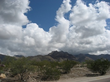
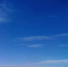
So that once it arrived at the target it would have the structure to form a strong cumulus cloud that could produce a rain event. (Photo taken in target area)
As simple as that method may sound there are still dozens of variables that can prevent the final outcome from happening over the designated target. Upper air currents have easily swept potential rain event hundreds of miles away to provide needed rain elsewhere. There are even bubbles of high pressure over some areas that act as equal magnetic poles preventing the rain event from landing on the target. There are many reasons for the areas of the world to be dry and they all conspire to continue the status quo.
The production of the rain laden clouds works. The method does produce substantial cumulus clouds. Just getting them onto a target area and getting the updrafts to produce the rain is our problem.
Other uses of the river
With this methodology in mind there are other applications that can be considered. Instead of only concentrating on rain production the question of severe weather abatement should be considered.
Here is a graphic of the ingredients for a tornado in the United States of America, the location of the world’s most and most severe tornados. Each spring all the ingredients form. Dry cold air from Canada, Dry hot air from Mexico, warm moist air from the Gulf of Mexico all combined by the jet stream. This year the United States witnessed the worst outbreak of tornadic activity in history. If any one of the ingredients could have been affected by weather modification the one most likely would be the dry hot air out of Mexico.
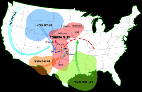
The above graphic perfectly illustrates the actions that take place in order to form tornadoes.
If this method could be perfected and scaled up, then the trigger (the “warm dry air”) could be modified to become either cooler and/or moister. There has been numerous research projects on what the ‘trigger’ is that makes one super cell storm yield killer tornadoes and another one of equal magnitude produce nothing but lots of lightning. To date, no one can agree on what makes a tornado. What all can agree on is that if even one element of a super cell is missing or diminished that the chances of it producing a tornado are dramatically reduced.
Conclusion
While large efforts and money are being allocated for localized weather modification, SciBlue is looking to use the tropospheric rivers to deliver rain to parched areas of the world now and possibly abatement operations of severe weather in the near future.
Instead of having to settle for what clouds are available over the target, we looks to create the needed clouds hundreds of miles from the intended target. Using a combination of an advanced weather model and augmenting existing clouds at precise times and locations in their infancy we attempt to produce results on a scale to exceed current seeding (glaciogenic) operations’ goals.
With our ongoing project in the arena of providing rain on target, we hope to investigate the use of the two technologies to attempt to abate severe weather.
Source: Climate abyss blog
Additional Resources on Atmospheric Rivers
- Weather Modification: from Cloud-seeding to Geoengineering
- Water 2025: Preventing Crises and Conflict in the West
Wikia: http://water.wikia.com/wiki/Water_2025
PDF: http://www.doi.gov/water2025/Water%202025-08-05.pdf
PDF: http://biodiversity.ca.gov/Meetings/archive/water03/water2025.pdf
![Potential Water Supply Conflicts by 2025 Potential Water Supply Conflicts by 2025]() [171] of Reclamation, Bureau U. S.. Water 2025: Preventing Crises and Conflict in the West. Washington, D.C.: U.S. Bureau of Reclamation, 2005.
[171] of Reclamation, Bureau U. S.. Water 2025: Preventing Crises and Conflict in the West. Washington, D.C.: U.S. Bureau of Reclamation, 2005. - Global Climate Change Impacts in the United States 2009 Report, Water Resources | Link
- Sierra Hydrometeorology Atmospheric River Experiment (SHARE) | Link
- Atmospheric Rivers | Link
- On tropospheric rivers | Link
- NOAA ESRL Atmospheric River bundle | Link
-
Are We Doomed to Wage Wars over Water? | Link
