Alma was queen for a day-for less than 24 hours on May 20 and 21, when the tropical storm blossomed briefly into a hurricane and thus became the second hurricane in this century to develop in the Atlantic, Caribbean, or Gulf of Mexico before the first of June.
An improved hurricane warning system and an intensive modification effort were ready for the precipitate 1970 season. The new aids available to the Weather Bureau’s National Hurricane Center include timely photographs from NASA’s Applications Technology Satellites, an improved pattern for aircraft storm reconnaissance, and a computer program to identify the coastal area most likely to be affected by a given storm.
Project Stormfury - the ESSA/Navy hurricane research and modification program- will attempt to seed hurricanes massively and repeatedly, to learn whether the force of these storms can be diminished. The Project’s major goal this season is to repeat the eyewall-seeding experiments conducted in 1969, in the hope of confirming the results. Other experiments planned for the 1970 season include seeding of hurricane rain bands and rain sectors, and continuation of experiments on lines of tropical cumulus clouds not associated with hurricanes.
Project Stormfury’s 1970 season will open July 23 after a “dry-run” rehearsal by participating aircraft from the Research Flight Facility, the Navy, and the Air Force. Thereafter, Stormfury scientists, planes, and flight crews will be on 48-hour alert for hurricane seeding through October 31.
Experiments will be conducted on storms in the south-western Atlantic, the Caribbean, and t he Gulf of Mexico, when the probability is small - 10 percent or less - that the hurricane center will come within 50 miles of a populated area during the ensuing 24 hours. The 24-hour period gives Project aircraft ample time to measure the effects of seeding before they are obscured by the proximity to land.
In 1969, on August 18 and again on August 20, Hurricane Debbie was seeded five times during an eight-hour period. These were the first such experiments conducted since 1961 and 1963, and the first ever to seed a storm more than once per day.
On August 18, Debbie was a mature hurricane with maximum winds exceeding 100 knots, located about 650 nautical miles east-northeast of Puerto Rico and moving toward the west-northwest.
Waiting for Debbie at Roosevelt Roads Naval Air Station, Puerto Rico, were 13 Project Stormfury planes - nine from the Navy, two from ESSA, and two from the Air Force. Debbie appeared to be an ideal subject for the Stormfury hurricane seeding experiment, except that the distance from Puerto Rico was an extreme range for heavily instrumented weather aircraft. With the 13 available aircraft, 14 flights were made. Of these, five carried the pyrotechnics to seed the hurricane and ten monitored the storm for changes in structure and intensity, from four hours before the first seeding until six hours after the last seeding.
 Hurricane Debbie, with eye clearly visible at left center of picture, photographed by ESSA 9 satellite.
In the two earlier experiments in 1961 and 1963, seeding began directly at t he eyewall with a single line of 80 large canisters of silver iodide dropped into the hurricane. In 1969, the seeding aircraft - a U.S. Navy A-6 Intruder flying at an altitude of 33,000 feet-penetrated the eye-wall to the area of maximum winds before starting to seed. Then , 208 smaller but more efficient silver iodide generators were dropped on a line extending across the outer wall and into the adjacent rain-bands which help to fuel the storm. Each of the five seeding runs lasted two to three minutes, covering a path 14 to 20 nautical miles in length.
The seeded storm was monitored by specially instrumented planes at several levels from 1000 to 37,000 feet. Flying at 12,000 feet, the two DC-6 aircraft of ESSA’s Research Flight Facility made repeated passes across the storm. In previous mature hurricanes, winds at the 12,000-foot level have been about 95 percent as strong as those near the surface.
Before the first seeding on August 18. maximum winds at 12,000 feet were 98 knots. After the second seeding, and again after the third, measured winds showed a decrease in intensity. Five hours after the fifth seeding, they were 68 knots- 31 percent less than before the experiment began .
There was no seeding on August 19. and the hurricane re-intensified. On August 20, the storm had a double eye, an unusual structure in hurricanes and complicated to handle with present seeding techniques. However , maximum wind speed at 12.000 feet before the first seeding was 99 knots , and after the final seeding it had dropped 15 percent, to 84 knots.
According to the theory on which these experiments are based, injection of silver iodide just outside the storm’s ring of maximum winds sets in motion a series of changes which cause the tremendous forces within the hurricane to work against each other. The silver iodide particles provide freezing nuclei for the large quantities of water that exist within the storm at temperatures far below freezing. As the super-cooled water is converted to ice, the freezing process releases heat energy into the storm system. Heat added in the proper sector of a hurricane should lower atmospheric pressure in the area next to t he storm’s low-pressure center. When the pressure differences within the hurricane are diminished, the strongest winds should weaken, and the energy formerly concentrated around the storm’s center should disperse over a larger area.
Stormfury scientists are not certain whether the decreases in wind speeds after the 1969 experiments were caused by the seeding, or whether they resulted from natural changes in the hurricane . But analyses of past storms show that the rate of decrease in wind speeds observed on August 1 8 would be very rare in an unseeded hurricane. The smaller decreases observed on August 20 could be expected to occur naturally in fewer than half of the unmodified storms. The fact that the storm’s winds diminished on both seeding days strongly suggests that at least some of the changes were caused by the modification experiment.
Both death and damage may be reduced substantially if the wind speed of hurricanes can be diminished as they approach land.
Since 1900, there has been a spectacular rise in hurricane caused property damage, primarily because of the increasing concentration of expensive buildings along vulnerable shore lines. During the 1960’s, hurricane damage in the United States alone has exceeded 4 one quarter billion dollars.
 "Storm room" of the National Hurricane Center where advisories and warnings are first issued.
According to Dr. R. Cecil Gentry, Director of ESSA’s National Hurricane Research Laboratory and of Project Stormfury : “If Federal hurricane modification research continues at the present level for a decade and if, in that time, one severe hurricane such as Camille in 1969 can be weakened so that its damage is reduced by as little as 10 percent, the in vestment will have been returned tenfold."
While the property damage has risen sharply, the death toll exacted in the United States by hurricanes has shown a tremendous decrease. as tracking. forecasting, and preparedness have improved . Hurricanes no longer sweep ashore without warning, as they once did, to snuff out thousands of lives .
During summer and autumn, the Atlantic Hurricane Warning Service, headquartered at t he National Hurricane Center in Miami, and ESSA Weather Bureau Hurricane Warning Offices at San Juan, New Orleans, Washington , and Boston, maintains a watch on tropical disturbances which could develop into destructive storms. ( A similar watch on Pacific hurricanes and typhoons is kept by Weather Bureau offices in San Francisco and Honolulu . )
The Miami Center analyzes and monitors t he progression of disturbances as they form half a world away and as they develop into full-fledged hurricanes about to strike the east or gulf coasts.
The Center’s Storm Room receives a constant flow of information from satellites, ship reports , air reconnaissance, radar, and other sources as t he great storms move closer to the main land.
A key element in the 1970 hurricane watch is the weather satellite. which enables forecasters to spot storm systems on a global scale, while they are still in the forma tive stage. The Center monitors cloud photographs from ESSA satellites and NASA’s Advanced Technology Satellites - ATS-I over the Pacific and A TS-3 over the Atlantic. From the A TS, in stationary earth orbit 22,300 miles over the Equator , photos of the same geographic area are received every 23 minutes. Operational use of the A TS pictures in hurricane forecasting was made possible by the recent installation of a new antenna at ESSA’s Wallops Island, Virginia , facility, and of a photo-facsimile circuit to transmit the pictures to Miami . The re, they are displayed on screen in still and movie-loop form, so scientists can study both t he shape and direction of storms.
When disturbances are within the range of aircraft, though still far out in the Atlantic, they are probed by reconnaissance planes of the Air Force, the Navy, and ESSA.
This year, for the first time, each plane probes not only the center but also each of the four quadrants of the storm system, following flight patterns which a re oriented to the movement of t he storm center. Data on such vital factors as temperature and pressure changes is transmitted directly to the Center. Constantly updated portraits of each storm’s vortex tell whether it is gaining or losing intensity .
As storms, tracked both by satellites and aircraft, move closer to shore, a radar “fence” covering the entire gulf and Atlantic coastlines and the lesser Antilles probes the atmosphere more than 200 miles over the ocean, providing another view of t he systems on the Storm Room screens .
In previous years. the decision to raise a hurricane watch has been a matter for the forecaster ’s subjective judgment. This season, a computer storing the history of all Atlantic hurricanes uses this data to project the probable t rack of an approaching system.
When the center of a hurricane is between 24 and 36 hours of possible land fall, a new hurricane analogy technique - HURRAN - will be called into action. This is a computer program which analyzes the behavior of all previous hurricanes located and moving in a manner similar to the one approaching the coast and computes the sector of the coastline which historically has a t least a 50-50 chance of being mauled by winds and storm surge. This will become the area for which t he National Hurricane Center will announce a hurricane watch. It is expected that watch times of up to 36 hours, and warning times of 15 to 1 8 hours. may be achieved by this technique.
The Miami Center offers local guidance to the offices at San Juan, New Orleans, Washington, and Boston with hurricane warning responsibility. These offices, and the National Meteorological Center at Suitland, Maryland, are linked by special communications which focus on hurricane warning action from June 1 through November 30.
Each of the four hurricane warning offices is assigned a specific coastal area for which it issues public advisories and bulletins on hurricanes and tropical storms. This is a team effort between the warning offices and the National Hurricane Center.
Hurricane Emergency Information Centers w ill be established this yea r in cities threatened by hurricanes. The service is a program of the ESSA Office of Public Information, in cooperation with the Weather Bureau’s Emergency Warnings Section, National Hurricane Center, and Eastern and Southern Regions. Manned by information officers working under the direction of the local meteorologist in charge, the centers will provide a constant flow of official, accurate information and advisories to the news media during the weather emergency.

Last year, the Weather Bureau set a record, by preparing the largest number of hurricane advisories ever issued to the public in one season. Hurricane reconnaissance aircraft of the Air Force, Navy, and Research Flight Facility devoted more flight hours to storm tracking than in any previous yea r.
The storms themselves prompted this high level of activity. For the first time since 1953 when the Weather Bureau began giving hurricanes girls’ names, enough tropical storms occurred to use the names through the letter M. Of these 13 storms, 10 reached hurricane intensity-winds of 74 or more miles per hour. And one-Camille-was t he most destructive in the history of Atlantic hurricanes.
Debbie will be remembered as the subject of Project Stormfury’s seeding experiments.
Other oddities made last year’s season unique in hurricane history. A sounding balloon was released into the eye of Francelia as it crossed Swan Island in the Caribbean, a feat accomplished only four times before.
Inga was the longest-lived Atlantic hurricane on record, drifting for 25 days within a relatively small area over the open Atlantic.
Kara could n’t decide where she was going, and became the first hurricane to cross her own path three times.
Laurie was the first ever to enter the Gulf of Mexico and die without bringing winds of at least gale force to any shoreline.
Martha, the year’s last storm, was the first observed to move inland on the north coast of the Republic of Panama.
But the season’s big one was Camille - a hurricane that set new marks for storm tides, barometric pressure, and property damage.
Reconnaissance aircraft measured a minimum pressure in the storm of 905 millibars ( 26 .61 inches) - the lowest of record measured by aircraft instruments in an Atlantic storm. Crossing the coastline along the G ulf of Mexico, Camille created record high storm tides of 24.6 feet, and there is evidence that the water level actually may have been a few feet higher than that. One of the most destructive storms ever to hit the United States, Camille caused a total of 256 deaths, and damage estimated at $1 .42 billion. The damage equaled that of Hurricane Betsy which struck southern Florida and Louisiana in September 1965, and its death toll was the highest since Hurricane Audrey took 390 lives in Texas and Louisiana in June 1957.
Thus, Camille became one for the record books, the name being retired from the four-year rotating list of hurricane names . This is the rule for all major hurricanes affecting the United States.
In the 1970 season, Alma has come and gone. The other names awaiting storms in the Atlantic, Caribbean, and Gulf of Mexico are Becky , Celia, Dorothy, Ella, Felice, Greta, Hallie, Isabel, Judith, Kendra, Lois, Marsha, Noreen, Orpha, Patty, Rena, Sherry, Thora, Vicky, and Wilna. No one knows how many of these names will be used before the season ends, or which ones - if any - may make history this year.
But the nation’s hurricane warning system is ready for them .
source: ESSA - July 1970 Volume 5 Number 3
Also see: Project STORMFURY: A Scientific Chronicle 1962 - 1983 - Text Version
Dig in to the Weather Control Timeline!
WeatherModificationHistory.com
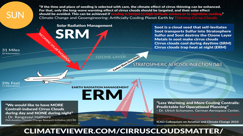
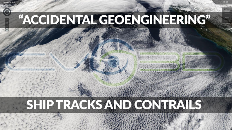
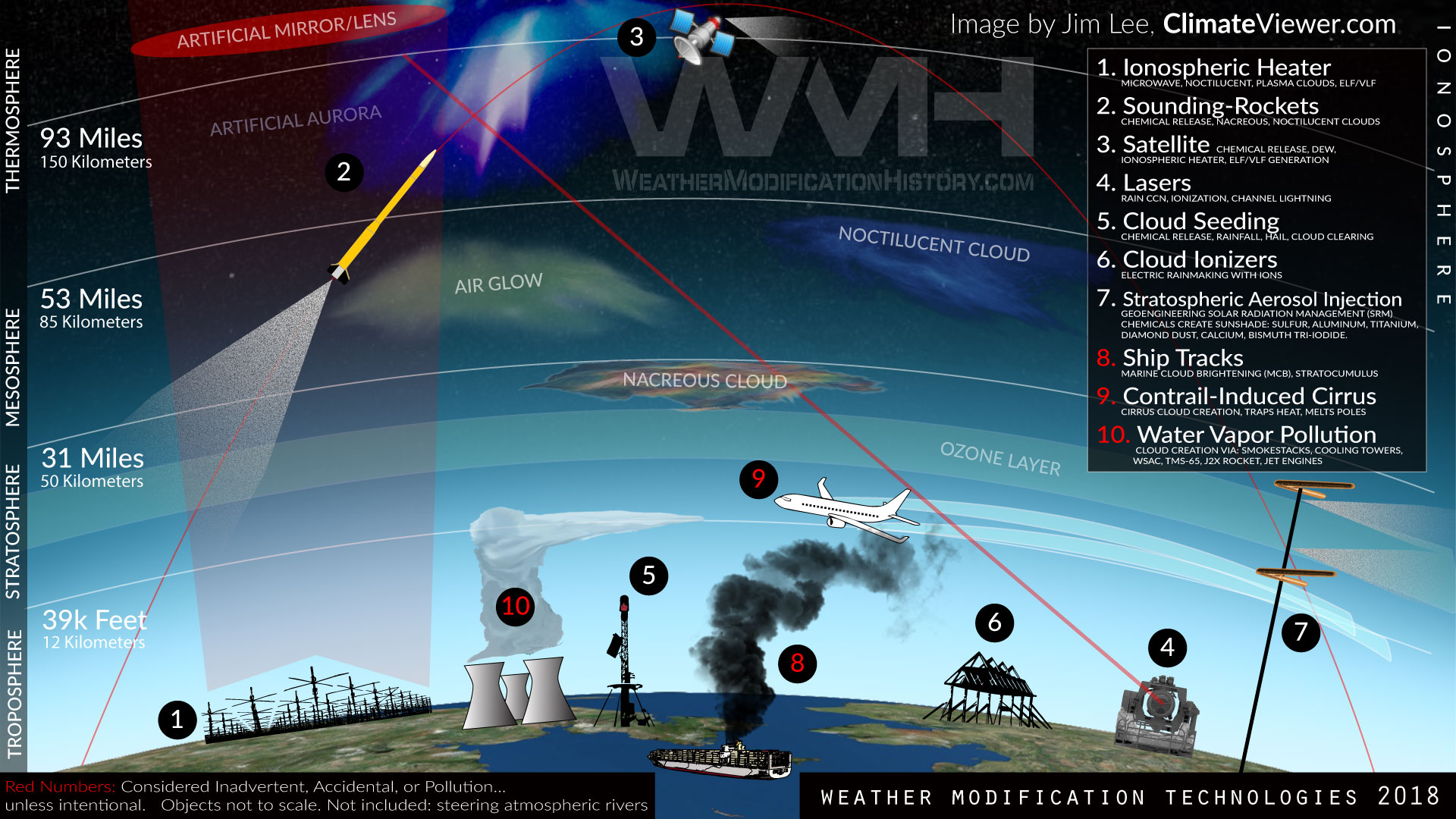
Never heard of Geoengineering?
Geoengineering and Weather Modification Exposed
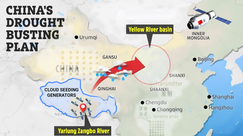
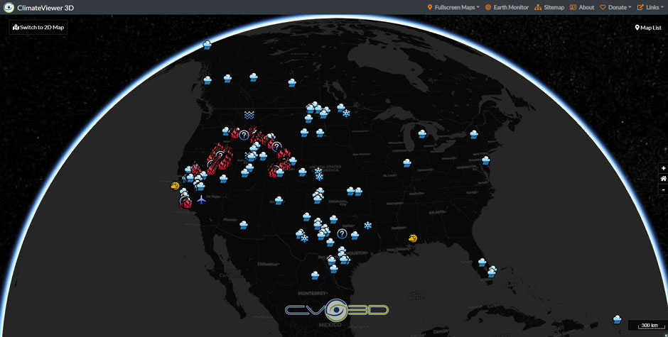
Weather Modification Experiment Map
Weather modification activities worldwide are also available on our maps.

“I am forever a Boy Scout, lifetime artist, nocturnal programmer, music is my life, love is my religion, and I am the luckiest husband and father on Earth. I speak for the trees. I have a passion for mapping, magnets, and mysteries.”
About Jim Lee")